
Page 6 - Geomorphological_2020
P. 6
6 M. PAPPALARDO ET AL.
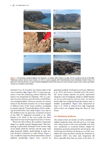
Figure 4. Outstanding coastal landforms and deposits. (a) marine cliff in Pirreca Locality; (b) the southernmost tip of the Mid-
Pleistocene marine terrace (Case Canino); (c) MIS 5.5 marine deposit with Persististrombus latus individuals (Scindo Passo); (d)
tidal notch (Cala San Nicola) (e) waves breaking highlightvermetid reefs along the south-western coast; (f) storm waves-generated
boulder accumulation (Cala Pozzo).
elevation of ca. 30 m borders the western slope of the gastropod mollusk Dendropoma petraeum (Balistreri
main mountain ridge (Figure 4(b)). A steep scarp sep- et al., 2015), that forms a vermetid reef in the interti-
arates it from the underlying western tableland. This dal. Active marine deposits are poorly represented
feature was interpreted by Malatesta, 1957 as a pro- along the coast of Favignana. Sandy or pebbly beaches
duct of marine abrasion and referred to a Mid-Pleisto- are rare as active features and very small. An inactive
cene interglacial phase. Moreover, patches of a marine beach ridge was recognized along the western coast. A
terrace at the elevation around 2 m a.s.l were mapped boulder accumulation (Figure 4(f)) interpreted by
in different tracts of the Island coastline, overlapped Pepe et al. (2018) as derived from high magnitude
by marine deposits (Ventura Bordenca, 2014) contain- storm waves was mapped along the shore in Cala
ing Persististrombus latus shells (Figure 4(c)), that in Pozzo.
the Mediterranean are generally considered exclusive
of the MIS 5.5 highstand (Antonioli et al., 2006;
4.6. Weathering landforms
Repetto et al., 2020). In the cross profile (see Main
Map inset) its best morphological expression is shown. The ramps surfaces are mostly carved by rounded and
Where the cliff is absent, the coastline is frequently shallow rockpools, from a few dm up to ca. 2 m long/
shaped as a gently seaward dipping ramp. This mor- wide. Being located in the lower supratidal zone, they
phology is particularly developed at the western edge were interpreted as erosional features shaped by
of the Island. Both the cliff face and the ramp outer elementary processes promoted by aerosol spray. Salt
edge frequently display, undercuttings at mean sea- weathering and wetting and drying are normally con-
level elevation interpreted as tidal notches (Figure 4 sidered the main processes causing the formation of
(d)). Locally the ramp is bordered seaward by a narrow rockpools (2007). Sea water may temporarily fill
platform morphology (Figure 4(e)), covered by them, especially those that are closer to the shore. In