
Page 4 - Geomorphological_2020
P. 4
4 M. PAPPALARDO ET AL.
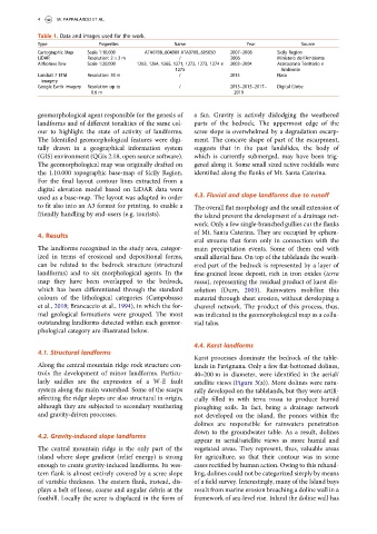
Table 1. Data and images used for the work.
Type Properties Name Year Source
Cartographic Map Scale 1:10,000 ATA0708_604080 ATA0708_605050 2007–2008 Sicily Region
LiDAR Resolution: 2 × 2 m / 2006 Ministero dell’Ambiente
Airbornes b/w Scale 1:20,000 1263, 1264, 1265, 1271, 1272, 1273, 1274 e 2003–2004 Assessorato Territorio e
1275 Ambiente
Landsat 7 ETM Resolution: 30 m / 2015 Nasa
imagery
Google Earth imagery Resolution up to / 2013–2015–2017– Digital Globe
0.6 m 2019
geomorphological agent responsible for the genesis of a fan. Gravity is actively dislodging the weathered
landforms and of different tonalities of the same col- parts of the bedrock. The uppermost edge of the
our to highlight the state of activity of landforms. scree slope is overwhelmed by a degradation escarp-
The Identified geomorphological features were digi- ment. The concave shape of part of the escarpment,
tally drawn in a geographical information system suggests that in the past landslides, the body of
(GIS) environment (QGis 2.18, open source software). which is currently submerged, may have been trig-
The geomorphological map was originally drafted on gered along it. Some small sized active rockfalls were
the 1.10.000 topographic base-map of Sicily Region. identified along the flanks of Mt. Santa Caterina.
For the final layout contour lines extracted from a
digital elevation model based on LiDAR data were
used as a base-map. The layout was adapted in order 4.3. Fluvial and slope landforms due to runoff
to fit also into an A3 format for printing, to enable a The overall flat morphology and the small extension of
friendly handling by end-users (e.g. tourists). the island prevent the development of a drainage net-
work. Only a few single-branched gullies cut the flanks
of Mt. Santa Caterina. They are occupied by ephem-
4. Results
eral streams that form only in connection with the
The landforms recognized in the study area, categor- main precipitation events. Some of them end with
ized in terms of erosional and depositional forms, small alluvial fans. On top of the tablelands the weath-
can be related to the bedrock structure (structural ered part of the bedrock is represented by a layer of
landforms) and to six morphological agents. In the fine-grained loose deposit, rich in iron oxides (terra
map they have been overlapped to the bedrock, rossa), representing the residual product of karst dis-
which has been differentiated through the standard solution (Durn, 2003). Rainwaters mobilize this
colours of the lithological categories (Campobasso material through sheet erosion, without developing a
et al., 2018; Brancaccio et al., 1994), in which the for- channel network. The product of this process, thus,
mal geological formations were grouped. The most was indicated in the geomorphological map as a collu-
outstanding landforms detected within each geomor- vial talus.
phological category are illustrated below.
4.4. Karst landforms
4.1. Structural landforms
Karst processes dominate the bedrock of the table-
Along the central mountain ridge rock structure con- lands in Favignana. Only a few flat-bottomed dolines,
trols the development of minor landforms. Particu- 40–200 m in diameter, were identified in the aerial/
larly saddles are the expression of a W-E fault satellite views (Figure 3(a)). More dolines were natu-
system along the main watershed. Some of the scarps rally developed on the tablelands, but they were artifi-
affecting the ridge slopes are also structural in origin, cially filled in with terra rossa to produce humid
although they are subjected to secondary weathering ploughing soils. In fact, being a drainage network
and gravity-driven processes. not developed on the island, the ponors within the
dolines are responsible for rainwaters penetration
down to the groundwater table. As a result, dolines
4.2. Gravity-induced slope landforms
appear in aerial/satellite views as more humid and
The central mountain ridge is the only part of the vegetated areas. They represent, thus, valuable areas
island where slope gradient (relief energy) is strong for agriculture, so that their contour was in some
enough to create gravity-induced landforms. Its wes- cases rectified by human action. Owing to this rehand-
tern flank is almost entirely covered by a scree slope ling, dolines could not be categorized simply by means
of variable thickness. The eastern flank, instead, dis- of a field survey. Interestingly, many of the Island bays
plays a belt of loose, coarse and angular debris at the result from marine erosion breaching a doline wall in a
foothill. Locally the scree is displaced in the form of framework of sea-level rise. Inland the doline wall has