
Page 3 - Gueguen_alii_2010
P. 3
498 E. GUEGUEN ET ALII
(fig. 1). All these structures occur within a 400-km long,
150-km wide deformation belt, bounded by the E-W trending
UEL and KAL fault zones (fig. 1). The exposed portions of
NW SE trending faults in the Egadi Islands and in northern
Sicily exhibit marked dextral strike-slip kinematics (ABATE et
alii, 1998; RENDA et alii, 1999, 2000; GUARNIERI, 2004, and
references therein). The activation of N-S, E-W and NW-SE
trending fault systems is generally referred to the Early
Pliocene-Recent interval (BOCCALETTI & DAINELLI, 1982;
GHISETTI & VEZZANI, 1984; FINETTI & DEL BEN, 1986; CAR-
BONE & GUARNIERI, 2003; LENTINI et alii, 2006).
DATA PRESENTATION
New insights into the kinematics and dynamics of the
southern Tyrrhenian Sea margin can be derived by integrat-
ing geophysical, structural and geodetic data. In this section,
after a brief review of the available geophysical information
derived from the literature, we present the results of inde-
pendent, original structural and space geodesy data analyses.
GEOPHYSICAL DATA
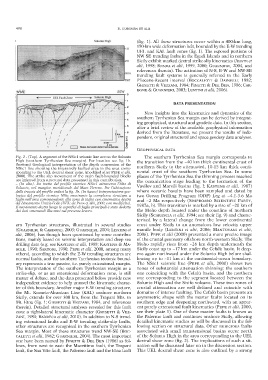
Fig. 2 - (Top). A segment of the NSic1 seismic line across the Solunto The southern Tyrrhenian Sea margin corresponds to
High (southern Tyrrhenian Sea margin). For location see fig. 1b. the transition from the ~40 km thick continental crust of
(bottom) Geological interpretation of the depth conversion of the
NSic1 line showing the intensively faulted area in the area corre- northern Sicily to the attenuated, 10-15 km thick conti-
sponding to the UEL dextral shear zone. (modified after PEPE et alii, nental crust of the southern Tyrrhenian Sea. In some
2000). The strike slip movement of the main fault-bounded blocks places of the Tyrrhenian Sea the thinning process reached
are inferred from structural data presented in this contribution. the oceanization stage leading to the formation of the
– (In alto). Un tratto del profilo sismico NSic1 attraverso l’Alto di
Solunto, nel margine meridionale del Mare Tirreno. Per l’ubicazione Vavilov and Marsili basins (fig. l; KASTENS et alii, 1987)
della traccia del profilo vedasi la fig. 1b. (In basso) Interpretazione geo- where oceanic basalts have been sampled and dated by
logica del profilo sismico NSic mostrante la complessa struttura a two Ocean Drilling Program (ODP) Leg at ~4.1-3.6 Ma
faglie nell’area corrispondente alla zona di taglio con cinematica destra and ~2 Ma respectively (SHIPBOARD SCIENTIFIC PARTY,
del Lineamento Ustica-Eolie (UEL: da PEPE et alii, 2000, con modifiche).
Il movimento destro lungo le superfici di faglia principali è stato dedotto 1987a, b). This transition is marked by a rise of ~20 km of
dai dati strutturali illustrati nel presente lavoro. the Moho depth located under the coastline of northern
Sicily (SCARASCIA et alii, 1994; see their fig. 9) and charac-
terised by a lateral change from the lower continental
ern Tyrrhenian structures, illustrated in several studies crust under Sicily to an anomalous low velocity upper
(GUARNIERI & CARBONE, 2003; GUARNIERI, 2004; LENTINI et mantle body (LENTINI et alii, 2006; MANTOVANI et alii,
alii, 2006), has though been questioned by some contribu- 2006). PEPE et alii (2000) presented a more precise image
tions, mainly based on seismic interpretation and deep sea of the crustal geometry offshore north-western Sicily. The
drilling data (e.g. see KASTENS et alii, 1988; KASTENS & MA - Moho rapidly rises from ~26 km depth underneath the
SCLE, 1990; SARTORI, 1990; PEPE et alii, 2000, among many Sicily coast up to ~17 km under the Cefalù basin. It deep-
others), according to which the E-W trending structures are ens again northward under the Solunto High before shal-
normal faults, and the southern Tyrrhenian tectonic bound- lowing up to ~11 km at the continental-ocean boundary.
ary represents a true passive, i.e. purely extensional, margin. The NSic1 seismic line (PEPE et alii, 2000) shows two
The interpretation of the southern Tyrrhenian margin as a zones of substantial attenuation thinning: the southern
strike-slip, or as an extensional deformation zone, is still one coinciding with the Cefalù basin, and the northern
matter of debate, and the data presented below provide new one corresponding to the segment located between the
independent evidence to help unravel the kinematic charac- Solunto High and the Sisifo volcano. These two zones of
ter of this boundary. Another major E-W trending structure, crustal attenuation are well defined and coincide with
the Mt. Kumeta-Alcantara Line (KAL) onshore northern domains of intense faulting. The Cefalù basin presents an
Sicily, extends for over 300 km, from the Trapani Mts. to asymmetric shape with the master faults located on its
Mt. Etna (fig. 1; GHISETTI & VEZZANI, 1984, and references southern edge and deepening northward, with an appar-
therein). Detailed structural analyses revealed for this fault ent purely extensional fault kinematics (PEPE et alii, 2000,
zone a right-lateral kinematic character (GHISETTI & VEZ- see their plate 1). One of these master faults is known as
ZANI, 1984; BARRECA et alii, 2010). In addition to N-S trend- the Palermo fault and continues onshore Sicily, allowing
ing extensional faults and E-W trending strike-slip faults, detailed kinematic studies as will be discussed in the fol-
other structures are recognised in the southern Tyrrhenian lowing section on structural data. Other numerous faults
Sea margin. Most of these structures trend NW-SE (BOC- associated with small transtensional basins occur north
CALETTI et alii, 1982; GUARNIERI, 2004). The most important of the Solunto High in the area corresponding to the UEL
one have been named by FINETTI & DEL BEN (1986) as fol- dextral shear zone (fig. 2). The implications of such a sit-
lows, from west to east: the Marettimo fault, the Trapani uation will be discussed later on in the discussion section.
fault, the San Vito fault, the Palermo fault and the Etna fault This UEL dextral shear zone is also outlined by a strong