
Page 6 - Gueguen_alii_2010
P. 6
THE SOUTHERN TYRRHENIAN SEA MARGIN 501
Separate data analyses have been performed first for
each technique (VLBI, GPS and SLR) and then the solu-
tions were combined. In fact, once the geodetic solutions
have been obtained, it is important to define a common
reference frame prior to comparing and combining the
results. Therefore the different solutions have been trans-
formed and combined within the ITRF97 reference frame
(BOUCHER et alii, 1999). Then residual velocities with
respect to the Eurasian block have been computed sub-
tracting the rigid motion of Eurasia defined by 13 ITRF97
stable sites located in central Europe and expressed in the
ITRF97 reference frame (DEVOTI et alii, 2002).
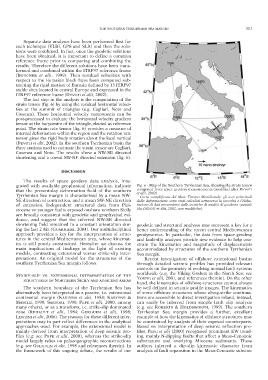
The last step in the analysis is the computation of the
strain tensor (fig. 6) by using the residual horizontal veloci-
ties at the summit of triangles (e.g. Cagliari, Noto and
Cosenza). These horizontal velocity components can be
post-processed to evaluate the horizontal velocity gradient
tensor at the barycentre of the triangle, elected as reference
point. The strain rate tensor (fig. 6) provides a measure of
internal deformation within the region and the rotation rate
tensor gives the rigid body rotation about the local vertical
(DEVOTI et alii, 2002). In the southern Tyrrhenian basin the
three stations used to estimate the strain tensor are Cagliari,
Cosenza and Noto. The results show a NW-SE directed
shortening and a coeval SW-NE directed extension (fig. 6).
DISCUSSION
The results of space geodesy data analysis, inte-
grated with available geophysical information, indicate Fig. 6 - Map of the Southern Tyrrhenian Sea, showing the strain tensor
that the present-day deformation field of the southern computed from space geodesy measurements (modified after DEVOTI
et alii, 2002).
Tyrrhenian Sea margin is characterised by a mean NW- – Carta semplificata del Mare Tirreno Meridionale: gli assi principali
SE direction of contraction, and a mean SW-NE direction dalla deformazione sono stati calcolati attraverso la raccolta e l’elabo-
of extension. Independent structural data from Plei - razione di dati provenienti dalle tecniche di analisi di geodesia spaziale
stocene or younger faults exposed onshore northern Sicily (da DEVOTI et alii, 2002, con modifiche).
are broadly consistent with geodetic and geophysical evi-
dence, and suggest that the inferred NW-SE directed
shortening field remained in a constant orientation dur- geodetic and structural analyses may represent a key for a
ing the last 2 Ma (GUARNIERI, 2004). Our multidisciplinal better understanding of the recent central Mediterranean
approach provides a key for the interpretation of struc- geodynamics. In particular, the data from space geodesy
tures in the central Mediterranean area, whose kinemat- and fault-slip analyses provide new evidence to help con-
ics is still poorly constrained. Hereafter we discuss the strain the kinematics and magnitude of displacements
main implications of findings in the light of existing accommodated by structures of the southern Tyrrhenian
models, contrasting extensional versus strike-slip inter- Sea margin.
pretations. An original model for the structures of the Recent investigation of offshore extensional basins
southern Tyrrhenian Sea margin follows. through detailed seismic profiles has provided relevant
controls on the geometry of evolving normal fault systems
worldwide (e.g. the Viking Graben in the North Sea: see
STRIKE-SLIP VS. EXTENSIONAL INTERPRETATION OF THE
YOUNG et alii, 2001, and references therein). On the other
STRUCTURES OF NORTHERN SICILY AND ADJACENT AREAS
hand, the kinematics of offshore structures cannot always
The southern boundary of the Tyrrhenian Sea has be well defined in seismic profile images. The kinematics
alternatively been interpreted as a passive, i.e. extensional of some offshore structures whose along-strike continua-
continental margin (KASTENS et alii, 1988; KASTENS & tions are accessible to direct investigation inland, instead,
MASCLE, 1990; SARTORI, 1990; PEPE et alii, 2000, among can easily be inferred from simple fault slip analysis
many others), or as a transform, i.e. strike-slip dominated (e.g. see ROBERTS & HOLDSWORTH, 1999). The southern
zone (RÉHAULT et alii, 1984; GUEGUEN et alii, 1998; Tyrrhenian Sea margin provides a further, excellent
LENTINI et alii, 2006). The reasons for these different inter- example of how the kinematics of offshore structures may
pretations may in part reflect differences in the analytical be constrained by analysis of their exposed counterparts.
approaches used. For example, the extensional model is Based on interpretation of deep seismic reflection pro-
mainly derived from interpretation of deep seismic pro- files, PEPE et alii (2000) recognised prominent EW trend-
files (e.g; see PEPE et alii, 2000), whereas the strike-slip ing, mainly N-dipping faults that affect a Meso-Cenozoic
model largely relies on palaeogeographic reconstructions substratum and overlying Miocene sediments. These
(e.g. see GUEGUEN et alii, 1998 and references therein). In authors inferred a dip-slip kinematic character from
the framework of this ongoing debate, the results of our analysis of fault separation in the Meso-Cenozoic substra-