
Page 5 - Gueguen_alii_2010
P. 5
500 E. GUEGUEN ET ALII
tion of the Gratteri-Mt. Mufara Line through time could
account for its present NNW-SSE trend, that is anom-
alous with respect to the generai NW-SE trend of adja-
cent Marettimo, Trapani, San Vito and Palermo faults. In
summary, all structural data collected along the Maret-
timo, Trapani, San Vito and Palermo faults indicate for
these structures a dominant dextral, strike-slip kinematic
character. These elements are consistent with the hypoth-
esis of a sub-horizontal, NW-SE directed shortening field.
SPACE GEODESY DATA
The improvement of the space geodetic techniques, in
particular Very Long Baseline Interference (VLBI) and
Global Positioning System (GPS) during the last decades
provides us with a fundamental tool for studying present-
day geodynamics even in zones whose movements are
slower than those from «fast» (i.e. Pacific-type) areas
(WARD, 1994; ZARRAOA, 1999, among others). The central
Mediterranean area is one of the best places to test this new
tool because of the density of the permanent GPS network
and the availability of other space geodetic techniques
(VLBI and/or Satellite Laser Ranging, SLR) in some sta-
tions (Matera, Medicina, Noto and Cagliari). Previous
works on geodetic data measured by these fixed stations
have been published (DEVOTI et alii, 2002; HAAS et alii, 2000,
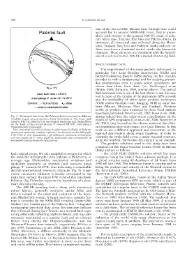
Fig. 5 - Structural data from the Palermo fault measured at different among others) but, like other recent contributions on the
localities (equal area projection, lower hemisphere). The mean fault results of GPS campaigns (CALAIS et alii, 2000, NOCQUET et
trend is N133°E, whereas the mechanical striations and slickenfibres
on the fault surface mean plunge 8° toward NI29°E, indicating a alii, 2001), they focused on the relative motion of the differ-
transtensional component. ent acquisition sites with respect to a fixed Eurasia. In this
– Dati strutturali raccolti in diverse località lungo la Faglia di Palermo work we use a different approach and concentrate on the
(proiezione equiareale, emisfero inferiore). La direzione media della faglia regional deformation along single baselines, in order to
è N133°E; le strie meccaniche e gli indicatori cinematici immergono
con un angolo di 8° verso N129°E, indicando una componente di constrain the strain field across a major regional structure,
movimento prevalentemente transtensiva. using the southern Tyrrhenian Sea margin as an example.
The geodetic solutions used in this study have been
computed at the Space Geodesy Centre (CGS) in Matera
(Italy) and are as follows:
fault-related gouge. We only sampled structures for which – the «CGS VLBI EUR98» solution which has been
the available stratigraphic data indicate a Pleistocene or computed using the CALC/f-Solve software package. It is
younger age. Slickensides, mechanical striations and a global solution using 42 databases of 24 hours from
slickolites measured on selected fault surfaces mean 1990 till late 1998. The reference frame is constrained by
plunge 8° towards N129°E, thus indicating a remarkable fixing the position and velocity of the Wettzell station to
dextral transtensional kinematic character (fig. 5). A per- the International Terrestrial Reference Frame ITRF96
vasive cataclastic foliation is locally associated to the (BOUCHER et alii, 1998);
main fault surface; the mean E-W trend of this cataclastic – the CGS GPS analysis, based on the Italian Space
foliation (fig. 5) further supports the hypothesis of a dom- Agency (ASI) permanent GPS network, which is part of
inant dextral strike-slip. the EUREF (EUropean REference Frame) network and
The NW-SE trending faults, along with associated contributes on a regular basis to the EUREF realization.
minor fabrics, generally overprint earlier folds and The data are routinely analyzed at the CGS using a Fidu-
thrusts related to the onset and evolution of the Apen- cial Network analysis method with the software Micro-
nine-Maghrebide system. A longer and more complex his- Cosm vs. 9800 (VAN MARTIN, 1998). The analyzed time
tory is recorded by the NNW-SSE trending Gratteri-Mt. series runs from January 1995 till May 1999. A network
Mufara Line, located east of the Palermo fault. Integrated solution has been performed to obtain station coordinates
stratigraphic-structural data along this structure indicate on a daily basis. The terrestrial reference frame has been
that it formed during Late Triassic as a normal fault sepa- strictly constrained to ITRF96 (BOUCHER et alii, 1998);
rating differently subsiding platform blocks, and was sub- – the global «SLR CGS98L01» solution, based on the
sequently reactivated as a transfer fault and as a lateral reduction of the world wide range observations to the
thrust ramp during the Oligocene-Miocene and the Lageos I and Lageos II satellites. The time series covers a
Miocene-Pliocene time intervals, respectively (RENDA et time span of 14 years ranging from January 1984 to
alii, 1999; TAVARNELLI et alii, 2001, 2003; BUTLER et alii, December 1998.
2006). Moreover, a diffuse seismicity in the Madonie
Mountains (FREPOLI & AMATO, 2000) suggests that the For complete description of the solutions the reader is
Gratteri-Mt. Mufara Line, i.e. the main tectonic feature of referred to LANOTTE et alii (1999), FELMI et alii (1997),
this area, was further reactivated in more recent times BOUCHER et alii (1998), BIANCO et alii (1998) and DEVOTI
and could still be active. This history of repeated reactiva- et alii (2002).