
Page 20 - angeo-21-299-2003
P. 20
318 R. Sorgente et al.: Seasonal variability in the Central Mediterranean Sea circulation
39 (a)A) (b)B)
39
38 38
37 37
North Latitude
North Latitude
36 36
35 35
34 34
33 33
0.2 m/s 0.2 m/s
32 32
9 10 11 12 13 14 15 16 17 9 10 11 12 13 14 15 16 17
East Longitude East Longitude
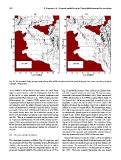
Fig. 19. The simulated 10-day averaged total velocity field at 280 m depth in (a) February and (b) August. One vector every four grid points
is plotted. Units are m/s.
of the MAW is shifted further south where the shelf break Fig. 15 shows the presence of the LIW in the Sicilian Chan-
slope is more tenuous, with the consequence that the fate nel with a typical salinity of more than 38.7 psu (in agree-
of the MAW is more probable to branch southward and ment with Grancini and Michelato (1987); Warn-Varnas et al.
southeastward (Warn-Varnas et al., 1999), feeding the mid- (1999); Sparnocchia et al. (1999)) at about 400 m depth. In
Mediterranean jet. Poulain (1998) reports that in winter, the Channel the LIW stream is strongly controlled by the to-
Langrangian drifters deployed upstream in the Sicilian Chan- pography. It enters the area at about 15–16◦ E, close to the
nel tended to avoid the Malta Channel route and proceeded Medina sill where the sea bottom rises from a depth of over
south-southeastward to eventually reach the Ionian. In agree- 2000 m to a mean of around 400 m. The morphology obliges
ment with Horton et al. (1997a) and Robinson et al. (1999), the LIW to pass along the southern proximity of Malta and
the model results show that the northward veering of the to subsequently spread again as it reaches the flanks of Ad-
MAW over the Malta Escarpment is also observed in spring venture Bank. Before reaching the Strait of Sicily, the LIW
and fall. This is in contradiction with earlier studies, such follows a path through the Channel of Pantelleria, and sub-
as Tziperman and Malanotte-Rizzoli (1991) and by Ovchin- sequently proceeds through the wider Tunisian sill, reach-
nikov (1966), who conclude that, on exiting the Channel, the ing up to the bottom at 450 m depth. The isohalines below
MAW proceeds predominantly to the north during summer, 200 m are generally unchanged, with an inclination toward
and to the south and southeastward during the remainder of the Tunisian coast throughout the year, as visible in Fig. 16.
the year. In this figure the LIW is visible below 300 m with a salinity
maximum of 38.7 psu and well comparable with the observa-
4.4 The intermediate circulation tions by Sparnocchia et al. (1999) in the same area.
The simulated circulation at 280 m (Fig. 19) replicates well Beyond the Strait of Sicily, the entire LIW turns eastward
the westward LIW flow. The variability of the LIW is limited due to the presence of the Skerki Bank and enters the Tyrrhe-
mainly to the intensity of the flow rather than to its spatial nian Sea where the simulated speeds reach their highest val-
location, in agreement with the diagnostic studies by Sor- ues in winter. The same path for the LIW was observed by
gente and Zavatarelli (2002). The vertical section at 13◦ E in Sparnocchia et al. (1999) from CTD data gathered in Novem-
ber 1993. From the southern Tyrrhenian Sea one branch