
Page 10 - 23
P. 10
ARTICLE IN PRESS
1576 K. Lambeck et al. / Quaternary Science Reviews 23 (2004) 1567–1598
Grado Lagoon 29 30 Aquileia
Caorle Lagoon 27 28 Tagliamento
Conselice 26 25 North Adriatic
Sea
1 Versilia Plain
2 Castiglioncello
Adriatic
Sea
3 Argentarola Island
Gravisca 4 5 Punta della Vipera
20 North sardinia
6 Roma
7 Anzio
Fondi 9 8 Torre Astura
21 Caccia C. Tyrrhenian 10 Volturno 24 Egnazia
11 Pozzuoli 23 Sibari
19 Orosei Sea
Palinuro C. 12
Briatico 13 22 Rizzuto C.
S. Vito Lo Capo 17 16 Zafferano C. Scilla 14 Ionian
Marettimo I. 18 Sea
15 Taormina
31 Djerba
Uplift + 51/+160 m Main thrust and
Uplift + 11/+50 m transpressional faults
Stable + 0/+10m
Subsidence - 1/-120m Main normal
and transtensional faults
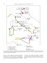
Fig. 1. Locations of the Italian sea-level sites (numbers correspond to Table 1) and the summary of the elevations of the MIS 5.5 shorelines relative
to present sea level. Dashed colour coded lines refer to areas where the information is uncertain. The red area 25 defines the Adriatic core site
locations. The principal faults are also shown.
lies in the rocky coastal zone of northern Tuscany (À300 AD). The altitude of the MIS 5.5 shoreline
(Galoppini et al., 1996). The quarry is carved down is a few meters above present sea level (Nisi et al.,
to 1.7 below present sea level and is archaeologically 2003) and we assume that the area has been tectonically
related to the Late Hellenistic period at B2.3 ka BP stable.