
Page 6 - Spatial _distribution_Brugnano_2010
P. 6
Author's personal copy
316 C. Brugnano et al. / Journal of Marine Systems 81 (2010) 312–322
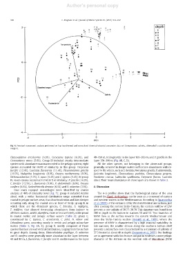
Fig. 4. Principal component analysis performed on log-transformed and normalised chemical–physical parameter data set (temperature, salinity, chlorophyll a and dissolved
oxygen).
Clausocalanus arcuicornis (6.9%), Corycaeus typicus (6.3%), and 40–150 m, H. longicornis in the layer 100–200 m, and P. gracilis in the
Ctenocalanus vanus (5.6%). Group III included mostly intermediate layer 150–300 m (Fig. 8B, C, D).
species with abundance maxima recorded in the pelagic system; eight All the other species, not belonging to the above-said groups,
species accounted for 64.9% of similarity in this group: Corycaeus generally, occurred in deeper waters with scarce abundances with re-
furcifer (12.4%), Lucicutia flavicornis (11.4%), Pleuromamma gracilis spect to the others, such as S. dentata, Neocalanus gracilis, P. abdominalis,
(10.7%), Haloptilus longicornis (6.0%), Oncaea mediterranea (6.0%), Lucicutia longicornis, Clausocalanus paululus, Clausocalanus pergens,
Oithona atlantica (5.7%), C. vanus (5.4%) and C. typicus (5.4%). In group Eucalanus crassus, Lubbockia squillimana, Corycaeus flaccus, Lucicutia
IV, seven species accounted for 63.61% of similarity: P. gracilis (16.3%), clausi. Their mean abundances in these layers are shown in Table 3.
C. furcifer (12.5%), L. flavicornis (9.9%), P. abdominalis (8.0%), Oncaea
conifera (6.5%), Scolecithricella dentata (6.5%) and O. atlantica (3.9%). 4. Discussion
Four main copepod assemblages were identified by cluster
analysis at 46% of similarity level (Fig. 7): group A included Acartia The θ–S profiles show that the hydrological status of the area
clausi, with a wider horizontal distribution range extended from around the Egadi Archipelago can be seen as a crossroad of eastern
coastal to pelagic surface areas, than Acartia adriatica and Isias clavipes and western waters in the Mediterranean. According to Sparnocchia
occurring only along the coastal area in front of Sicily; group B, in et al. (1999), at the entrance of the Western Mediterranean Basin, just
which there are the dominant species, C. furcatus, A. negligens, after crossing the section Sicily–Tunisia, the eastern outflow of LIW
T. stylifera, that showed decreasing abundances from inshore to presents a core salinity of 38.77–38.78. This signature was found from
offshore stations, and O. plumifera, more or less uniformly widespread 300 m depth to the bottom in stations 10 and 12. Two branches of
in coastal neritic and pelagic surface waters (Table 2); group C, MAW flow at the surface towards the eastern Mediterranean and
constituted by C. typicus, C. arcuicornis, C. jobei, N. minor and cross the Sicily–Tunisia section (Astraldi et al., 1999), where the
Calocalanus pavo, occurring mostly in neritic and pelagic subsurface presence of MAW is characterized by a high seasonal variability. In
waters (Table 3; Fig. 8A, E); group D, mostly composed of those late summer, the smaller stream along the southern Sicilian shelf
species that had a broad vertical distribution, ranging from the surface presents a subsurface core characterized by a minimum of salinity of
to great depth. Among these, Heterorhabdus papilliger, O. atlantica 37.3 located at about 40 m depth (Sorgente et al., 2003). Our findings
and O. conifera were generally more abundant in the layer between are in agreement with this feature and put in evidence a more pelagic
40 and 80 m, L. flavicornis, C. furcifer and O. mediterranea in the layer character of the stations on the western side of Marettimo (DCM